 |
 |
| current issue |  |
past issues |  |
send a letter/news |  |
address update |  |
advertise |  |
about us |  |
alumni home |
Campus Currents
Seeking the Tsunami's SourceBy Robert Emro
Imagine trying to fly a remote control airplane in the dark, and you'll have some idea of what an international team of the world's leading scientists had to do to find and film critical seafloor ruptures that contributed to the deadly tsunami that struck Asia on Dec. 26, 2004.
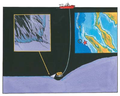
That's why the group of 22 scientists from six countries wanted researchers from UNH's Center for Coastal and Ocean Mapping and Joint Hydrographic Center around when they sent a remotely operated vehicle 4,500 meters down into the Indian Ocean to bring back the first photographic evidence of the seafloor faults.

|
The team's professional drivers, accustomed to following man-made structures like pipelines with a remotely operated vehicle, needed help when it came to tracking geographical features, explains center co-director Larry Mayer, who was joined by UNH visualization researchers Roland Arsenault and Colin Ware on the expedition. Although they could see live video from the vehicle's camera, the perspective could be deceiving, in effect making mountains out of mole hills.
The expedition was filmed by a United Kingdom company for a joint documentary by the BBC, the Discovery Channel and ProSieben, a German television company. "Journey to the Heart of the Tsunami" is expected to be aired later this year.
The expedition focused its attention on the southern part of the earthquake rupture zone that caused the tsunami. Although thousands of kilometers long, the fault is not always visible. After hours of searching, they finally found dramatic evidence of the earthquake—a prominent cliff that was thrust upwards during the enormous earthquake and undoubtedly contributed to the creation of the tsunami wave.
It is the first time that marine scientists have been able to find and film such critical ruptures at such an incredible depth in the Indian Ocean. "We saw clear evidence of the earthquake that caused the tsunami," says Mayer. "It was just as likely that we would get down there and see nothing."
A pioneer in seafloor imaging, Mayer helped the tsunami modelers update the on-board supercomputer's model with data on the underwater topography, which exerts a tremendous effect on a tsunami's behavior. "They saw the data in ways they've never seen it before," he says. "They had just been working with grids of numbers." Ware was the expedition's "freelance visualizer," says Mayer, creating images as needed, such as a video recreation of an underwater landslide caused by the earthquake.
The UNH researchers also got a chance to visit some of the areas where the tsunami struck hardest, including Phuket, Thailand. "We saw one town that was really devastated," says Mayer. But what was most heartrending, he says, was how there was a complete lack of destruction just a short walk away. "All people had to do was get inland, and that's the real problem, that people didn't know to do that," he says.
Easy to print version
blog comments powered by Disqus

