 |
 |
| current issue |  |
past issues |  |
send a letter/news |  |
address update |  |
advertise |  |
about us |  |
alumni home |
Short Features
Hunt and PeekScientists track down how much global-warming carbon dioxide a forest can absorb
by David Sims

|
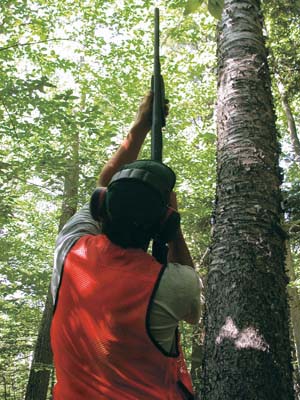
It is mid-August in New Hampshire's White Mountains, and Scott Ollinger '92G, '00G, Mary Martin '88, '94G and Marie-Louise "M.L." Smith '00G, shotguns in hand, are stalking Acer rubrum on Plot 32-P of the 2,600 acre Bartlett Experimental Forest. The crack of distant gunfire cuts through the air and fades away. Here on 32-P, Ollinger looks skyward, squints down the length of the barrel, and yells out "Another maple!" much the way a pool player announces the intention of putting the eight ball in the side pocket. Fellow hunter-gatherer Smith scribbles notes on a brown paper bag that will hold their quarry. Ollinger aims, shoots and scores. Through a haze of blue-gray smoke, splintered branches and leaves peppered with bullet holes flutter 70 feet down from the crown of the tall red maple tree that Ollinger, a UNH research assistant professor, has just bagged as part of a national climate change research effort called the North American Carbon Program. The hills are alive with the sound of science.
What would appear to be fieldwork in the style of John James Audubon or Charles Darwin is, in fact, cutting-edge stuff. That's because, while Ollinger, Martin, also a UNH research assistant professor, and Smith, a research ecologist with the U.S. Department of Agriculture's Forest Service, surgically remove leaves using 12-gauge steel birdshot, a modified U2 spy plane hurtles through near-space, 70,000 feet up in the stratosphere, doing some shooting of its own.
The high-flying NASA ER-2 Airborne Science plane photographs the canopies of 32-P's trees with a "hyperspectral" instrument called AVIRIS, short for Airborne Visible-Infrared Imaging Spectrometer. AVIRIS uses a whopping 242 bands of visible and infrared light to "read" the chemical content of leaves. By comparison, the instrument aboard the Landsat 1 satellite that gave us our first remote glimpse of Earth in the early 70s created images using a mere seven spectral bands.

|
What Ollinger and company are composing is a large-scale picture of forest productivity in the White Mountains, using the combined data gathered from a chemical analysis of top-layer tree leaves and spectral images from AVIRIS. The ultimate goal of the research is to determine just how much carbon and nitrogen are being released and stored by this big chunk of woodland and beyond, information that is critical to understanding, and dealing with, climate change and global warming. Over the last few years, the scientists have shot leaves and spectral images from New England to the Catskills, from Florida to New South Wales, Australia, honing the technique and gathering data.
Page: 1 2 Next >Easy to print version
blog comments powered by Disqus

