 |
 |
| current issue |  | past issues | | send a letter/news | | address update | | advertise | | about us | | alumni home |

Features
Final FrontierPage 3 of 5
Meanwhile, things can get interesting once underway. In 2004, the Healy got stuck in 30-foot-deep ice above 80 degrees north latitude. The dispiriting options included a call to the Russians for help (they own the world's most powerful icebreakers) or a prolonged Shackleton-like stay on the ice waiting for a thaw. Eventually, after 10 hours of body-rattling collisions, the ship bucked and rammed its way through. During the most recent Arctic mission, the Healy pounded against an ice ridge 36 times over the course of two hours before finally rumbling through. Days earlier, as a result of accumulated ice damage to equipment on both vessels, a U.S. Coast Guard C-130 flew in crucial repair parts, airdropping three packages on an adjacent ice floe. One scientist puts the working conditions this way: You don't have to be crazy to do science in the Arctic, but it helps.
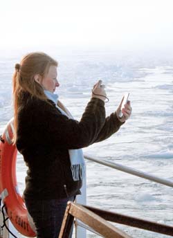 Andy Armstrong photo PERSONAL RECORD: Graduate student Christy Fandel takes a photo of her phone's GPS position as the Healy reaches the most northern point of the expedition. |
An Arctic voyage is also an opportunity. So on this trip, as with several previous ones, Mayer has invited "riders" who are doing all manner of ancillary science projects: everything from high-Arctic bird inventories to ocean acidification readings to video intelligence on the ice conditions ahead using hand-launched, hand-caught 2.5-pound Raven drones left over from Afghanistan. He also coordinated a rendezvous with Canadian scientists aboard the icebreaker Louis S. St. Laurent—each vessel taking turns breaking ice for the other's experiments.
While Mayer makes it clear that mapping the seafloor is the main goal, he's plainly pleased at so much going on under his watch: he wants to cram in as much science as possible. In the hydrographic universe he is well known for his mantra: one survey, many uses. Here in the Arctic, the variation might be: one big ship, many, many uses.
His inclusiveness extends to another presence: the media. The team's work does not take place in a vacuum, Mayer believes. Public outreach is part of UNH's mission, and, in addition, more opportunities arise when the world knows what they're up to. Mayer is a natural: a good storyteller and a concise and self-deprecating explainer. He also comes across as a regular guy. In the Anchorage airport, he has the high-speed McDonald's run down cold. The veteran science producer for the National Geographic film crew was flummoxed when a guy named Larry left him a message saying he'd be there to pick him up at the airport in Barrow: "I went back to check the record—I thought it had to be a different Larry. I've never had a chief scientist offer to come get me at the airport before."
 Perry Smith/UNH Photographic Services |
WHAT NATIONAL GEOGRAPHICand others are increasingly interested in is the newly opening Arctic and the impact that Mayer's work will have in delineating who owns what. The mapping of millions of square kilometers of Arctic seafloor is the result of the U.N. Convention on the Law of the Sea, which gave Arctic-abutting nations 10 years to map their Arctic seabeds. The big question for scientific teams from Russia, Canada, the United States, Denmark and Norway is how far into the Arctic their respective continental shelves extend. Using multibeam sonar technology and analysis of seafloor samples, each team will put together a claim based on data from dozens of cruises. Next up may be the hardest part: reaching a multinational political agreement over a resource-rich portion of the world.
It seems the 21st-century version of settling disputed borders involves not armies but mapmakers. Mayer regards that as progress—an exercise that is civil and often collaborative. That said, the work isn't entirely without tension. In 2007, the Russians used a mini-sub to plant a flag on the seafloor underneath the North Pole. After he returned from the expedition, a Russian polar scientist was quoted in USA Today as saying, "I don't give a damn what all these foreign politicians there are saying about this... The Arctic has always been Russian." Soon thereafter, Mayer and Calder were at Boston's Logan Airport preparing to board a plane for their polar cruise when a woman hustled up to them, having noticed their U.S. Arctic military-style parkas. "Are you going up to the Arctic to stop the Russians?" she asked. "Yes, ma'am!" replied Mayer, snapping to.
Even the naming of things can lead to vigorous debate. On a 2009 cruise, a 3,280-foot seamount was discovered by Canadian and U.S. vessels in tandem. The find was significant, but naming it required consensus. Ultimately, Mayer nominated "Mt. Cooperation." The Canadians eventually countered with the Inuktitut word Savaqatigiik. (Asked what it means, Mayer says with a smile: "Cooperation.")
Page: < Previous 1 2 3 4 5 Next >
Easy to print version