 |
 |
| current issue |  | past issues | | send a letter/news | | address update | | advertise | | about us | | alumni home |

|
Inquiring Minds By David Brooks Illustrations by Michael Sloan |
Easy to print version |
In this issue:
Love Thy NeighborAir Support
Mercury Sleuth
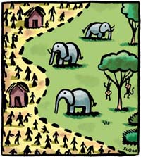
Love Thy Neighbor
How Ugandan farners cope with a wildlife park
|
It's called the Yellowstone Model, and for a century it has guided the development of national parks worldwide. Draw boundaries around a valuable area and keep most people out to save the wildlife and vegetation inside. But as Joel Hartter knows from his research in Uganda, cooperation by those excluded is vital.
"It's very analogous to what's going on in Yellowstone, where the ranchers right next door hate it because the wolves are coming over and killing their sheep," says Hartter, an assistant professor of geography who has been traveling to Uganda since 2005 to survey farmers living around the Kibale National Park, a small but ecologically rich jungle area near Congo. His goal is to get a better handle on how the park has altered the lives of people in this crowded region--which has one of the highest population densities and growth rates in Africa--to help guide the Uganda Wildlife Authority.
The problem in Kibale isn't wolves: it's monkeys, chimpanzees, baboons and elephants. These are thriving, proving a benefit both to the environment and to the Ugandan economy through tourism dollars. But they're a headache to small farmers because the animals leave the park to eat crops. Understandably, people in the region resent this.
There's another reason for resentment: Thousands of families were forcibly evicted when the park was created in 1993. Yet Hartter says once you get beyond the park's immediate neighbors, plenty of farmers are in favor of Kibale. "They believe there are ecological benefits," says Hartter. "They think they get more rain, and that it's at the right time of year, because of the park. They think it affects soil fertility, regulates the local climate and brings fresh air."
Nobody knows if these claims are true--in fact, in parallel research work, Hartter has begun establishing weather monitoring stations to try to get a handle on it, as well as to determine whether the region's climate is changing as a whole.
Hartter began this work well before he joined UNH in 2007. For two summers he lived at Makerere University Biological Field Station in the park for four months, traveling out daily with two assistants who belonged to the area's major ethnic groups, Bakiga and Batoro, to interview people in their villages. hout bias.
As with many field researchers, Hartter says an important step was earning the cooperation of locals. To foster that, he has returned to communities and talked about what he has found. "That did a lot to build trust," he says.
There is a long history of research around Kibale, where some work dates back to 1970, long before the park was created, and Hartter would like it to continue. Although he has cut back his visits to Uganda to a few weeks per year, and due to the imminent arrival of his second child may not go at all this summer, "I have local field assistants doing surveys, vegetation sampling, gathering GPS points for field boundaries and forests, things like that," he says. He is also in regular contact with other researchers who are using the field station and can carry material and messages for him to Uganda.
Not that communication is all that difficult: He can just call, because cell phones are wildly popular in much of Africa. "They get excellent phone reception," says Hartter. "Better than Durham."
Air Support
Where to put wind farms? Maybe a satellite can help
When the petroleum industry was born 150 years ago, it faced a problem: Up until then, oil hadn't been valuable, so nobody had bothered to figure out how to find it. Drillers had to wait for geological science to catch up before they could really get going. Today, the wind-power industry faces the same situation, especially offshore.
Graduate student Amanda Plagge is working with Doug Vandemark, aresearch associate professor in the Ocean Process Analysis Lab, to fill that gap. By using improved data from a NASA satellite, she hopes to give wind farms a relatively quick and easy way to decide where to put their turbines. "It's not hard to stick a pole in the middle of a corn field and measure the wind, but it's a different story offshore," she says. "We'd like to make satellite data as good as buoy data. It costs an awful lot to put out a meteorological buoy with all the instrumentation on it. It would be excellent to have another source of information."
The secret is QuikSCAT, a NASA satellite launched in 1999 that uses microwave radar in the Ku band, known as a "scatterometer," to measure wind speed and direction a short distance above the surface of the ocean. Recent advances have given the data much finer resolution, but there are still many questions about this new "product," as it's called. In particular, there's the important issue of how much it helps in coastal waters, where wind farms are easiest to place but where QuikSCAT has trouble sorting out reflections coming from land. Although the data contaminated by land can be removed with a special algorithm, coastal waters are tricky for other reasons, too.

|
"A scatterometer measures roughness of water and interprets that as wind," she says. "In the coastal ocean, though, you get other sources of roughness, such as current signals, water masses coming together and upwelling water."
Plagge's doctoral dissertation will focus on the difference between scatterometer measurements and readings from weather buoys--happily, buoys have been taking readings in the Gulf of Maine for a long time, which gives her plenty of data to work with--to help refine the analysis.
It's an interesting problem with potential applications to ocean modeling to help fisheries, or climate change research both at sea and on land. But as you might expect from somebody whose bachelor's and master's degrees are in electrical engineering, and who previously worked on the issue of de-icing small wind turbines, Plagge's has the pragmatic goal of helping bring offshore wind farms to reality. She has already had interest from one wind developer and expects to talk to more.
"Wind power has been frustrating so far, but I think things are going to break through," says Plagge. "There are a lot of projects in the permitting stages."
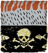
Mercury Sleuth
Tracking how a top toxin gets in the atmosphere
Mercury is sometimes known as quicksilver, because of the way this shimmering liquid metal skitters around and eludes capture. UNH researchers who are trying to pin down how this toxic metal gets into the environment have found that it can be pretty elusive when floating in the air, too.
The problem is that unlike most metals, which are solid in everyday conditions, mercury can exist in elemental, gaseous and liquid forms and in three different oxidation states. "That really complicates things," says Melissa Smith, an earth sciences doctoral candidate who is pondering three years of precipitation data from Thompson Farm in Durham to answer hair-splitting chemical questions about the role of various forms of the metal in environmental deposition.
|
This is no mere academic exercise. Mercury is one of the most dangerous of the toxins that have been spread by modern life, often from burning coal. Over the decades so much mercury has descended on New Hampshire from the atmosphere that eating too much fish from even the most pristine lakes and rivers can be dangerous (pregnant women are advised to eat none at all). As well as being dangerous, the problem is expensive: A scrubber system that is being installed on the state's biggest coal-fired power plant, Merrimack Station in Bow, will cost at least $450 million, and even it will only get rid of 80 percent of the mercury emissions.
No wonder a host of researchers around the world are studying the issue. "We're really trying to understand what processes in nature, enhanced by mankind, are controlling how mercury is deposited," says Julie Bryce, assistant professor of earth sciences.
At Thompson Farm, Smith's samples are collected by an automatic device in bottles made of Teflon because they must be cleaned with hot acid between sampling events to ensure no mercury lingers behind. After every "precipitation event," Smith hurries to swap out bottles ("I keep a close eye on the weather," she says), and analyzes the sample in a variety of ways.
She correlates the results with information about weather and atmospheric chemistry, aided by an adjacent meteorology station that is also part of UNH's AIRMAP climate-study program, and with data about the regional wind patterns over the previous five days. These help her hunt down the direction that mercury came from and the form it took during its atmospheric voyage. In particular, she is interested in "reactive gas-phase mercury," a highly soluble form of the element, and whether it contributes to mercury in rain. Her work so far indicates that, as many believe, it does: "They have speculated about it, but we are demonstrating it," she says.
Bryce thinks Smith's research will be something that "policy makers can look at when they are making decisions." If so, that will be fine with Smith. "I'm interested in projects that have practical applications," she says. Including, it seems, helping to pin down quicksilver. ~
blog comments powered by Disqus