 |
 |
| current issue |  | past issues | | send a letter/news | | address update | | advertise | | about us | | alumni home |

Campus Currents
|
Award-Winner
A web-mapping site developed by UNH and NOAA, gives researchers and the public access to all the information they ever wanted to know about the Deepwater oil spill By Suki Casanave '86G |
|
First responders tackling the recent Gulf oil spill had a new tool at their fingertips, literally, to help with the task—and it was developed with funding from the Coastal Response Research Center, a joint partnership between UNH and NOAA, the EPA Region II and the Coast Guard. The Environmental Response Management Application (better known as ERMA) is a GIS-based web tool that made it possible for responders to quickly click their way to critical information: Which fisheries were open? Where were the oil-covered sea turtles? What was the wind speed and wave direction? Where should we send the next batch of volunteers to help with beach clean-up? ERMA had the answers—and they could be accessed on the web from any computer.
"Before ERMA, critical information was scattered on paper or trapped in individual computers," says Michele Jacobi, an environmental scientist with NOAA's Assessment and Restoration Division, who led the first ERMA pilot project in Portsmouth Harbor in 2008. Two other projects followed, in the Caribbean and Puget Sound. With each simulated spill, ERMA was tested and refined.
"Over two years, we built ERMA into a stable product," says Patrick Messer '83, '85G, director of UNH's Research Computing Center (RCC), where the application was jointly created and hosted. "When NOAA decided to use it in the Gulf, we had a high degree of confidence that it would work."
When Jacobi called RCC's Bob St. Lawrence '00 to tell him NOAA wanted an ERMA site for the Gulf, he and colleague Phil Collins '02 had it up and running almost immediately. Within an hour, responders in the Gulf were uploading information. President Obama himself became familiar with ERMA when Jane Lubchenko, NOAA administrator, demonstrated the tool during White House briefing sessions. "If we hadn't developed a template through years of testing, it would have been impossible to go live this quickly for the Gulf," says Collins.
Before long, NOAA officials decided to go public. They wanted the spill information to be packaged for a wider audience—from Gulf Coast fishermen and recreational boaters to beach users and birders—providing a better understanding of how the government was responding to the crisis.
Lawrence and Collins worked nonstop for several weeks to prepare the public view of the ERMA site (geoplatform.gov/gulfresponse). Geoplatform provided a robust infrastructure to handle public access. The site now appears on NOAA's home page. When CNN reported on the user-friendly tool, traffic exploded, spiking to 3.4 million hits the first day. "We had six different servers accessing the database and there were so many hits per second, the database couldn't keep up," says St. Lawrence. "So we basically cloned the database, giving each of the six servers its own copy. We've been stable ever since."
In August, the site was voted one of the top 10 government web sites by Government Computer News and also was awarded the 2010 NOAA Administrator's and Technology Transfer Award. "ERMA is a huge part of the information management success story in the Gulf," says Amy Merten, NOAA co-director of the center. "The ability to present data and an easy-to-use map to the public wouldn't have happened without the center at UNH." ~
Several other NOAA/UNH centers contributed to ERMA, including C-COM's Kurt Schwehr, who developed the vessel-tracking component of ERMA, and nowCOAST, which provided synthesized weather and oceanographic web mapping services.
Learn more: www.geoplatform.gov/gulfresponse/video/
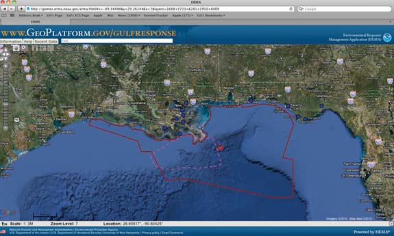 AWARD-WINNER: This spring, programmers at UNH's Research Computing Center quickly retooled an online application built for the Coastal Response Research Center and created a user-friendly way for the public to access a huge body of crucial data on the Gulf oil spill. Which fisheries were open? Where were the oil-covered sea turtles? What was the wind speed and wave direction? Following a CNN report, the site received 3.4 million hits in a single day. The site (www.geoplatform.gov) was recognized as one of the top 10 government websites by Government Computer News and also received the 2010 NOAA Administrator's and Technology Transfer Award. |
blog comments powered by Disqus