 |
 |
| current issue |  |
past issues | |
send a letter/news | |
address update | |
advertise | |
about us | |
alumni home |


Short Features
Mapping D-DayPage 2 of 2
Mayer and Calder were a logical choice for the Normandy job. UNH is a world leader in processing and visualizing multibeam sonar data. "This system is very expensive and very tricky to operate," says Calder, "so it's not something you can do without quite a bit of training." And the value of the multibeam had been demonstrated only months earlier during UNH's mapping of sunken World War I vessels in Scapa Flow, north of Scotland (see sidebar on page 16).
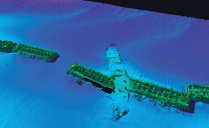 This sonar image shows a string of caissons on the ocean floor. The day after D-Day, hundreds of these caissons were towed across the channel and filled with water to create artificial harbors. This image also reveals a huge ship that sliced through a caisson like a knife during a catastrophic storm on June 19, 1944. - courtesy of Center for Costal and Ocean Mapping |
"The quality of the Scapa Flow images was part of what convinced me this would be worth doing," says Schmidt, who has been surveying the coast of Normandy for several years, using side-scan sonars, magnetometers and remotely operated vehicles.
Typical multibeam sonars take 100 to 130 depth measurements at once. Available for only a couple of years, the multibeam sonar used for the D-Day project takes 240 simultaneous depth measurements up to 40 times per second, generating a much clearer image.
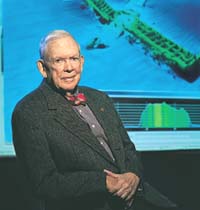 By the time the caissons were filled with water, Fred Hall was inland. Not until half a century later did Hall get a glimpse of this engineering feat. - courtesy of Center for Costal and Ocean Mapping |
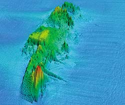
During their two weeks in Normandy, the survey team glimpsed several large ships on the ocean bottom, including the Meredith, the Partridge and the Susan B. Anthony, a personnel carrier that hit a mine the morning after D-Day. Minutes later, the ship went down. All 2,200 men on board were rescued--and went to war.
"The multibeam information provides a much clearer idea of the environment around the wrecks," says Schmidt. "In some cases, we were able to identify what had been only blurry in the side-scan images, like the trucks that were scattered next to a downed landing craft. That's what surprised me the most--the number of equipment vessels that were lost. Resupplying your forces during an invasion is so critical."
As stunning as the technology is, what made the project memorable was the context. "We sat there for 10 days," says Mayer, "looking back on the beaches, thinking about those poor young kids."
| Hunting for Historical Treasure |
|
November 1, 2002: Fred Hall sits in a darkened room inside UNH's ocean engineering building. Projected on a giant screen in brilliant yellows, blues and reds is an image of a Sherman tank, 60 feet below the surface of the ocean. With a click of a computer mouse, Larry Mayer adjusts the angle so Hall can make out the tank's gun, still aimed toward shore.
"The level of detail you're able to get is fantastic," says Hall. Mayer displays several more images. The talk is mostly technical and mundane--how sonar works, the names and locations of towns, the merits of French food. Then Calder projects an image of a sunken landing craft on the screen. Hall recalls how he ran down the ramp of his landing craft into the sea. Jim Dowd, a recent Harvard graduate, was running right next to him. And then, suddenly, he was gone. "Dowd was shot down as we reached the beach," Hall says.
More than half a century after landing at Normandy, Hall is matter-of-fact about his experience. "We did what we had to do, and that's pretty much the way it was," he says. But when he recalls his final glimpse of the beach, the day after the invasion, Hall's voice shifts. He speaks in measured tones, as if pacing himself. "The morning after D-Day, about daylight, I stood on the bluff, and from that vantage point I could see the beach--the bodies, the wreckage." Hall pauses. "That was enough for me. I never went back after that."
In 1981, Hall did, finally, return to Normandy. He stood on the very spot where he'd managed to climb off the beach on that awful day in 1944. "I'm not a weeper," he says quietly, "but it was an emotional visit." From the edge of the bluff, he gazed out across the expanse of sand, empty and still. Behind him, 9,700 white crosses stretched away to the horizon, each one marking the grave of an American soldier, each one a testament to the incalculable price of victory. ~
Page: < Prev 1 2Easy to print version
blog comments powered by Disqus