 |
 |
| current issue |  |
past issues | |
send a letter/news | |
address update | |
advertise | |
about us | |
alumni home |


Features
Portraits of the DeepPage 3 of 3
While Mayer studies the topography of the ocean bottom, Laurence "Laurie" Linnett, an electrical engineer from Heriot-Watt University in Edinburgh, Scotland, uses sonar to examine the makeup of the sea's subsurface, up to 60 feet below the ocean floor. Linnett, who will move across the Atlantic to join UNH's C-COM team, is an expert in signal processing—untangling the complexity of sound waves. He specializes in image analysis and synthesis, extracting information from sonar images.
"Imagine you were planning a garden in your back yard," he says. "You need to dig but want to avoid large boulders." This is precisely the dilemma faced by companies such as Simplex, in Portsmouth, N.H., which makes fiber-optic cable and lays it down across thousands of miles of ocean floor. They need to know if they'll be digging in mud or sand, silt or clay. The underwater sea plows used to lay cable are expensive—and can break if they run into a boulder. Accurate information about the composition of the ocean floor can save thousands of dollars.
Or suppose an oil company is interested in avoiding the expense of broken lines. One software program Linnett designed will detect potential weak spots in an underwater pipeline, creating images and pinpointing specific geographic locations so engineers can find and fix the problem—in a fraction of the time it used to require.
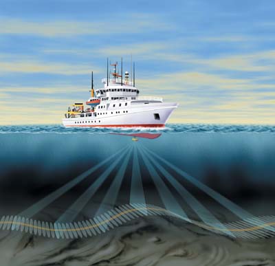 Mutibeam sonar produces so much data a CD-ROM is filled in an hour. |
Linnett's work has countless commercial applications, and he has worked with dozens of the world's largest companies. But for all the practical implications of his research, Linnett's primary goal is ever-improving data. "We are one of the only groups in the world doing this sort of work," he says. "We are developing new techniques for advanced sonar instruments that will build our vocabulary to communicate with the seabed."
For the past decade, Mayer and Linnett have been working on opposite sides of the Atlantic, developing different layers of an "information cake" about the ocean floor. At UNH, this research will finally come together in one place. The Jerry Chase Ocean Engineering Laboratory at UNH, home to some of the largest test tanks in New England, provides the ideal setting for developing new sonar equipment. And, with the expertise of Colin Ware, the increasing flood of sonar data will be integrated and presented in new ways that will allow viewers to peel back the layers, choosing data to "fly through" and examine. Together, these three researchers will lead C-COM in the exploration of new avenues and uses for ocean mapping.
UNH's C-COM team members are pioneers on the edge of what many consider the last great frontier. "We know more about the moon than we know about our own planet beneath the sea," says Linnett. "It's actually far easier to explore the moon. The deep-sea environment is harsh: several thousand feet down the pressure is intense—plus there are some pretty strange animals down there."
Though they rarely get their feet wet, UNH's "astronauts of the sea" will help to create and decipher images as mysterious and significant as the first handfuls of moondust picked up by the early space explorers. "Sometimes you see things," says Linnett, "and for a few minutes or hours, you're the only person in the world who's ever seen it." Thanks to UNH's new ocean mapping team, the rest of us, too, will be able to explore the mysteries of the deep—sailing through multicolored worlds on the wings of a flying mouse. ~
Suki Casanave '86G is a writer for the College of Engineering and Physical Sciences. She also writes for regional and national publications. She earned a graduate degree in literature from UNH.
Page: < Prev 1 2 3Easy to print version
blog comments powered by Disqus