 |
 |
| current issue |  |
past issues | |
send a letter/news | |
address update | |
advertise | |
about us | |
alumni home |


Features
Air HeadsIn the largest pollution study ever, more than a dozen UNH scientists are trying to understand the air we breathe
By David Sims '81
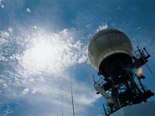 The R/V Ronald Brown's Doppler radar underneath a Portsmouth, N.H., summer sky.
|
Like all the other passengers, I board the jet with no ticket, no luggage and no destination. Oddly enough, this is no problem, even in the edgy, post-9/11 world, for this is no ordinary airplane.
We are in the National Aeronautic and Space Administration's DC-8 science aircraft, a 1966 commercial jet that has been converted into one of the world's most sophisticated flying laboratories. It's used for scientific studies ranging from archaeology to volcanology, but today's mission is to study the air around us.
Our flight, taking off from Pease International Tradeport in coastal New Hampshire, is one part of a six-week-long air quality study involving hundreds of scientists from around the world, including 20 researchers and 18 undergraduate and graduate students from UNH. The project—known as the International Consortium for Atmospheric Transport and Transformation, or ICARTT—is the largest air quality and climate study ever conducted. It seeks to better understand how pollution moves and changes as it makes its way across the North American continent, mixes and morphs in the coastal marine boundary layer, and then heads toward Europe.
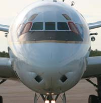 NASA's DC-8 jet, one of the world's most sophisticated flying laboratories.
|
Over the next eight hours, the DC-8 will make one gigantic loop down the East Coast to South Carolina, veering right towards Tennessee and Kentucky and heading into the monotonously flat checkerboard of Middle America. Somewhere over Illinois we will come about, nose into the Rust Belt and make for home. Along the way, the plane will buzz fishing vessels and farmers from a mere 1,000 feet, the four big jet engines bouncing up and down in gentle turbulence, silhouetted uncomfortably near the landscape below for 20 minutes at a time. It's like being on a perpetual runway approach and, as a result, tends to generate panicky phone calls from citizens alerting authorities that a commercial jet is about to crash. On occasion, the plane will fly as low as 300 feet to sample pollutants. Traveling at 335 miles per hour at such low altitudes requires keen eyes to scan for small, slow-moving airplanes.
While the project's particular focus is New England, air pollution observes no boundaries, says Berrien Moore III, director of UNH's Institute for the Study of Earth, Oceans and Space. "Air pollution is truly global in nature," he says. "What happens in Beijing will affect Boston, and vice versa." Earth-related science is moving from splintered, myopic, discipline-specific investigations, he says, toward a more comprehensive, interconnected, systems-based approach. Science, these days, ponders the big picture.
Because pollution created elsewhere often ends up here, New England is ignominiously referred to as the "nation's tailpipe." The dynamics of this pollution, its source and the mechanisms that transform and redistribute it are ICARTT's major goals. The study will also set the stage for regular air quality forecasts by the National Oceanic and Atmospheric Administration.
Page: 1 2 3 4 Next >
Easy to print version
blog comments powered by Disqus